

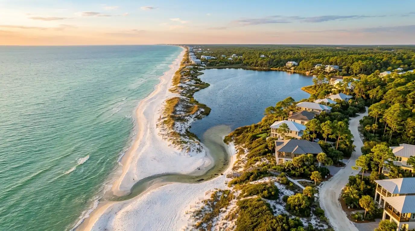
Waterfront on 30A and in Destin is five property types, not one: Gulf-front, Gulf-view, coastal dune lakefront, bay and bayou-front, and Destin Harbor-front. Each has its own value drivers and its own due diligence. Gulf-front is generally the highest-value waterfront category, but there is no reliable market-wide premium over Gulf-view, so we value both from very localized comparable sales. Boating property is only as good as the water, and flood and wind are two separate insurance questions.
Waterfront is the main focus of The Beasley Group, and we do not treat it as one category. Gulf-front, Gulf-view, lakefront, bayou-front and Harbor-front property have different valuation drivers, ownership considerations and due diligence. Our role is to show a buyer not only what water they are looking at, but what they can do with the property: whether the view is protected, what can be built, whether their boat can use the waterway, and what rights come with a dock or slip.
The five kinds of waterfront, compared
| Type | What it is | What drives value | What we check first |
|---|---|---|---|
| Gulf-front | Frontage directly on the Gulf beach | Community, lot width, beach frontage, elevation, construction and condition, architecture, beach access, rental potential | Where the coastal construction control line falls, the flood zone, the elevation certificate, the wind mitigation form |
| Gulf-view | A view of the Gulf without frontage | How permanent and how good the view is, elevation, the route to the beach, community | What sits between the home and the Gulf, who owns it and what can be built there |
| Coastal dune lakefront | Frontage on one of Walton County’s 15 named coastal dune lakes | Rarity, the lake itself, shoreline and dock rights | County shoreline rules, the outfall, the dock’s permit history, the lake’s current watercraft rules |
| Bay and bayou-front | Frontage on Choctawhatchee Bay or a bayou off it | Water depth at the dock, the route to East Pass at Destin, the dock itself | Depth at low water against the boat’s draft, bridge clearance, dock permits |
| Destin Harbor-front | Frontage on Destin Harbor, beside East Pass at Destin | Slip size and depth, position on the harbor | Slip dimensions and depth, whether the slip conveys with the property, dock permits |
Source: The Beasley Group’s waterfront valuation framework (team intake, September 2026); Walton County, Coastal Dune Lakes page (retrieved September 11, 2026); NOAA, U.S. Coast Pilot 5, Chapter 6 (edition dated September 6, 2026).
Gulf-front and Gulf-view: why we price from localized comparable sales
Gulf-front property generally represents the highest-value waterfront category in the 30A market, but there is no reliable market-wide percentage premium over Gulf-view property. Value changes dramatically with the community, lot width, beach frontage, elevation, home condition, architectural quality, beach access, rental potential and the permanence and quality of the view. We value Gulf-front and Gulf-view homes from very localized comparable sales rather than a standard waterfront premium.
Community is one reason a single premium misleads. Homes in Alys Beach, Rosemary Beach, WaterColor and WaterSound Beach can command luxury pricing without direct Gulf frontage, as our guide to what makes a 30A home a luxury home explains. So we compare a home with sales from its own community and position on the beach, not with a waterfront average.
Frontage also brings costs. Gulf-front homes can face added exposure from wind-driven water, erosion, salt and severe coastal conditions, so insurance and maintenance can meaningfully change the cost of ownership. And Gulf-front ownership has a seaward limit: under Article X, Section 11 of the Florida Constitution, the beach below the mean high-water line belongs to the state in trust for the public. Where the state has restored a beach, a fixed erosion control line can replace the mean high-water line as the boundary. Where a specific lot’s seaward line actually runs is a question for the deed, the survey and a Florida real estate attorney. Our guide to beach access in Walton County covers what that means on 30A.
Source: The Beasley Group’s valuation framework (team intake, September 2026); Florida Constitution, Article X, Section 11; Florida Senate Committee on Rules, bill analysis of CS/SB 1622 (2025); Stop the Beach Renourishment, Inc. v. Florida Department of Environmental Protection, 560 U.S. 702 (2010).
Protected views and what can be built in front of you
A Gulf view is worth what its permanence is worth. Before we call a view protected, we look at the land between the home and the Gulf: who owns it, what zoning and community rules allow there, and where the coastal construction control line falls.
The coastal construction control line
Section 161.053 of the Florida Statutes directs the Florida Department of Environmental Protection (FDEP) to set coastal construction control lines county by county along the state’s sandy beaches. Each line marks the part of the beach-dune system subject to severe fluctuations from a 100-year storm surge. Seaward of it, building any structure, excavating, changing ground elevations, driving across a dune or damaging dune plants requires a state permit or exemption. That covers a pool, a deck or a dune walkover as much as a house.
The line is a permit line, not a building ban. FDEP generally may not permit a major structure where its erosion projections put the site seaward of the seasonal high-water line within 30 years, but land seaward of the line can still be built on with a permit. For a Gulf-view buyer, the land in front of the home is regulated, not frozen.
Walton County’s current line took effect August 25, 2009, under Rule 62B-26.001 of the Florida Administrative Code. Okaloosa County’s line, which covers Destin, dates from January 8, 1992. FDEP’s Map Direct shows the line in solid red, and a survey shows it on a specific lot. Whether a property sits seaward of it is an address-by-address answer.
Source: Florida Statutes s. 161.053 (2026); FDEP, Locate the Coastal Construction Control Line (last modified December 4, 2025); Florida Administrative Code Chapter 62B-26.
Coastal dune lakes
Walton County has 15 named coastal dune lakes along 26 miles of coastline. The county says lakes like these are otherwise found only in Madagascar, Australia, New Zealand and Oregon, and the Florida Natural Areas Inventory ranks the habitat as globally imperiled. Lakefront lots are finite because the lakes are, and that rarity drives value.
The county’s list is Western, Eastern, Deer, Camp Creek, Powell, Fuller, Morris, Campbell, Stallworth, Allen, Oyster, Draper, Big Redfish, Little Redfish and Alligator. In our market, Western Lake sits between Grayton Beach and WaterColor, Eastern Lake is in Seagrove and Deer Lake sits just east of it, Big Redfish and Draper Lakes are in Blue Mountain Beach, Campbell, Morris, Oyster, Stallworth and Allen Lakes are around Dune Allen, Camp Creek Lake runs through WaterSound Beach, and Lake Powell, at Inlet Beach, straddles the Walton and Bay county line.
Outfalls, shoreline rules and jet skis
Each lake connects to the Gulf intermittently through an outfall, which Walton County describes as flood control: it releases lake water to the Gulf when levels are high, and salt water flows back depending on tides and weather. Digging in or around an outfall requires FDEP authorization under the coastal construction control line statute.
Walton County’s Land Development Code sets a Coastal Dune Lake Protection Zone around each lake. In the version the county posts online, dated 2019, seawalls, bulkheads, revetments and rip-rap are not permitted, clearing is limited, construction near the shoreline is limited to docks, boardwalks and a narrow access path, and nothing may be built in a lake’s natural outlet. We confirm the current code for the specific lot before a buyer plans a dock or an addition, and a dock also goes through the state rules below.
Western Lake, Eastern Lake and Lake Powell have public boat ramps, which the Choctawhatchee Basin Alliance guide hosted by Walton County describes as open to motorized boats. The same guide says jet skis are prohibited on all coastal dune lakes except the Bay County portion of Lake Powell, and Grayton Beach State Park does not allow jet-propelled watercraft at its Western Lake boat ramp. We confirm the current rule for the specific lake with Walton County before a buyer plans around a boat.
Source: Walton County, Coastal Dune Lakes page and rack card (retrieved September 11, 2026); Florida Natural Areas Inventory, Guide to the Natural Communities of Florida (2010); Choctawhatchee Basin Alliance, Coastal Dune Lakes of South Walton County (hosted by Walton County); Florida State Parks, Grayton Beach State Park, Experiences and Amenities (retrieved September 11, 2026); Walton County Land Development Code, Section 4.02.03 (posted version revised September 10, 2019).
Boating property: evaluate the water before the dock
We do not evaluate the dock without evaluating the water. Slip size, water depth, vessel draft, navigational access, dock permits and the route to open water can matter as much as the house itself.
Bay and bayou-front: depth and the route to the Gulf
Bay and bayou-front property on the 30A side sits on Choctawhatchee Bay. North of 30A, Santa Rosa Beach runs to the bay, where boat ramps and neighborhood docks in some communities are part of daily life. NOAA’s Coast Pilot describes the bay as about 25 miles long, with depths of 18 to 43 feet in the western two-thirds and 8 to 16 feet in the eastern third, away from the shores. A private dock sits near shore, so we measure depth at the slip at low water against the draft of the boat the buyer owns or plans to own.
The bay’s entrance from the Gulf is East Pass at Destin, which runs between Moreno Point and Santa Rosa Island and is protected by two jetties. NOAA warns that the channel south of the U.S. 98 bridge shoals rapidly between dredgings and advises local knowledge, which is why we do not quote a channel depth. The parallel U.S. 98 bridges over the pass have a least vertical clearance of 49 feet, which decides whether a sailboat’s mast can pass under them.
Destin Harbor-front
Destin began as a fishing village, and the harbor is still where the oldest part of Destin shows up. NOAA describes Destin Harbor as Old Pass Lagoon, a lagoon behind the spit on the east side of the entrance to East Pass at Destin, with several marinas. Harbor-front ownership sits inside a working waterfront of charter boats, marinas and restaurants. We check slip dimensions and depth against the boat, and whether the slip is part of the lot or assigned by an association or marina.
Dock permits and what passes to you
Florida exempts many private docks from a state environmental resource permit, but the exemption is narrow: 1,000 square feet or less over water (500 in Outstanding Florida Waters), on pilings or floats with no fill, no navigation hazard, recreational use only, and the only exempt dock within 65 feet of shoreline. It does not cover permission to use state-owned submerged land, which needs a separate authorization from the state Board of Trustees, or county requirements. FDEP or the Northwest Florida Water Management District reviews the state pieces. Federally, a dock in navigable waters needs U.S. Army Corps of Engineers authorization under Section 10 of the Rivers and Harbors Act of 1899.
Riparian rights, meaning ingress, egress, boating, bathing and fishing, attach to land whose title runs to the ordinary high-water mark of navigable water, and they pass to a buyer with that land whether or not the deed mentions them. A lot separated from the water by a common area, a road or another parcel may not carry them, so we confirm where the title line runs. A state environmental resource permit follows the property too, and the holder must notify the agency within 30 days of a change in ownership. Before closing, we ask the seller for the dock’s permit or exemption record, any submerged-land lease or consent, and any federal authorization.
Source: NOAA, U.S. Coast Pilot 5, Chapter 6 (edition dated September 6, 2026); Florida Statutes s. 403.813(1)(b) and s. 253.141(1) (2026); Rule 62-330.340, F.A.C.; FDEP Northwest District permitting page (retrieved September 11, 2026); 33 CFR 322.3.
Flood and wind are two separate questions
Being waterfront does not by itself tell you what insurance will cost. Elevation, FEMA flood zone, construction type, age, roof, mitigation features and replacement cost all matter. Florida’s required seller flood disclosure states that homeowners’ insurance policies do not cover floods, so flood is a separate policy from the National Flood Insurance Program (NFIP) or a private insurer. Wind is covered in a homeowners policy or a separate wind-only policy.
Flood zones set the rules, not the price
Zone VE, the Coastal High Hazard Area, is where waves and fast-moving water can cause extensive damage in a base flood. Zone AE marks at least a 1 percent annual chance of flooding with waves under 3 feet. Within Zone AE, the Coastal A Zone is where base-flood waves can reach 1.5 to 3 feet, and FEMA strongly recommends V-zone construction standards there. Zone X is moderate or minimal hazard. In NFIP communities, a federally backed mortgage on a building in an A or V zone requires flood insurance.
The zone no longer sets the NFIP premium. Under Risk Rating 2.0, in effect for new policies since October 1, 2021 and renewals since April 1, 2022, FEMA prices on flood frequency, flood types such as storm surge and coastal erosion, distance to water, elevation and rebuild cost, with most annual increases capped at 18 percent. An elevation certificate is optional but may lower the premium, so we ask the seller for one early. NFIP coverage tops out at $250,000 for the building and $100,000 for contents, and Florida lets private insurers write flood as an alternative or as excess coverage above that.
Citizens and the flood requirement
Citizens Property Insurance requires flood insurance on most personal residential policies that include wind. Homes in a FEMA Special Flood Hazard Area came under the rule in 2023. Outside it, the rule phased in by dwelling replacement cost and reached homes of $400,000 or more on January 1, 2026, and all remaining covered policies follow on January 1, 2027. Policies that exclude wind and condominium unit-owner policies are exempt. Citizens also offers wind-only policies in the former Florida Windstorm Underwriting Association area, which its PIWEST lookup checks by address.
Wind: the mitigation inspection form
Florida requires insurers’ rate filings to include discounts for wind mitigation features, and insurers must accept one statewide form for them: the Uniform Mitigation Verification Inspection Form, OIR-B1-1802, revised effective April 1, 2026. It records the building code at permit, roof covering, roof deck and roof-to-wall attachment, roof shape, secondary water resistance and the weakest opening protection on the house. A home with openings that need replacement does not qualify for the mitigation rate differentials at all. We ask for the seller’s latest form and, where it matters, a new inspection.
My Safe Florida Home, the state’s free inspection and grant program, does not fit a 30A second home. It requires an owner-occupied home with a homestead exemption, and its grants also require an insured value of $700,000 or less, construction before 2008 and a low- or moderate-income applicant. Our guide to buying a second home on 30A covers the decisions that come first.
Source: FEMA, Features of Flood Insurance Rate Maps in Coastal Areas (May 24, 2021); FEMA, NFIP’s Pricing Approach (updated April 9, 2026); FEMA, Understanding Elevation Certificates (March 2023); FloodSmart policy page (retrieved September 11, 2026); Florida Statutes s. 627.351(6), s. 627.715, s. 627.0629, s. 627.711 and s. 215.5586 (2026); Rule 69O-170.0155, F.A.C. (effective April 1, 2026).
The two Florida disclosures on waterfront sales
The flood disclosure, section 689.302
Since October 1, 2024, a Florida seller of residential property must give the buyer a prescribed flood disclosure at or before the time the contract is signed. SB 948 expanded it effective October 1, 2025. The seller marks has or has not for three items: knowledge of flooding that damaged the property during their ownership, a flood-damage claim with any insurer including the NFIP, and flood-damage assistance from any source, including FEMA. For sellers, it belongs in the listing file before the first offer. Our guide to selling a home on 30A covers the rest of that preparation.
The coastal properties disclosure, section 161.57
For property partly or wholly seaward of the coastal construction control line, the seller must also give a written coastal properties disclosure at or before contract. It states that the property may be subject to coastal erosion and to rules on the control line, rigid coastal protection structures, beach nourishment and marine turtle protection. At or before closing, the seller provides an affidavit or survey showing the line unless the buyer waives it in writing. The statute says missing paperwork does not affect the contract’s enforceability, so confirm the line yourself.
Source: Florida Statutes s. 689.302 and s. 161.57 (2026); Laws of Florida ch. 2024-215 (HB 1049) and ch. 2025-166 (SB 948).
Due-diligence checklist by waterfront type
Every waterfront property
- Pull the effective flood map for the address from FEMA’s Flood Map Service Center.
- Ask for the elevation certificate, the flood disclosure and the latest wind mitigation form.
- Quote flood and wind separately before the inspection period ends, against replacement cost.
Gulf-front
- Locate the coastal construction control line on FDEP’s Map Direct and on the survey, and read where the deed and survey put the seaward boundary.
- Confirm whether the house sits in Zone VE or the Coastal A Zone.
- Check permits for any walkover, pool or deck seaward of the line.
- Budget for salt, wind-driven water and erosion.
Gulf-view
- Identify every parcel between the home and the Gulf and who owns it.
- Check what zoning, community rules and the control line allow on those parcels.
- Walk the route to the beach access you will actually use.
Coastal dune lakefront
- Confirm which lake the lot fronts and where its outfall sits.
- Read the current county protection zone rules before planning a dock or addition.
- Get the existing dock’s permit or exemption record.
Bay, bayou and Destin Harbor-front
- Measure depth at the slip at low water against the boat’s draft, and match slip length and width.
- Trace the route to East Pass at Destin; from the bay side that route passes under the U.S. 98 bridges, so check mast height against their 49-foot clearance.
- Confirm whether the slip is part of the lot or assigned, and how it conveys.
- Collect the state permit or exemption, any submerged-land authorization and any Army Corps authorization.
For how we approach the rest of a purchase, see our buyer resources.
Frequently asked questions
What is the difference between Gulf-front and Gulf-view property on 30A?
Gulf-front property sits directly on the beach, with frontage on the Gulf. Gulf-view property sees the Gulf without owning frontage, usually from behind the front row. Gulf-front raises questions Gulf-view usually does not, such as where the coastal construction control line falls and how exposed the house is to waves and erosion. Gulf-view value depends on how permanent the view is, which turns on what can be built between the home and the Gulf.
Is Gulf-front property on 30A worth the premium over Gulf-view?
It depends on the property, which is why The Beasley Group does not quote a standard premium. Gulf-front generally represents the highest-value waterfront category on 30A, but there is no reliable market-wide percentage premium over Gulf-view. Value changes with the community, lot width, beach frontage, elevation, condition, architecture, beach access, rental potential and how permanent the view is. We price both from very localized comparable sales.
What should I know before buying a home on a coastal dune lake on 30A?
Walton County has 15 named coastal dune lakes. Each connects to the Gulf intermittently through an outfall, and digging in or around one requires a state permit. The county’s posted land development code, dated 2019, bars seawalls, bulkheads and rip-rap near the lakes and limits shoreline building to docks, boardwalks and an access path. A Choctawhatchee Basin Alliance guide the county hosts says jet skis are prohibited except on the Bay County portion of Lake Powell. Confirm current rules with Walton County and get the dock’s permits.
Can you use a jet ski on a 30A coastal dune lake?
Plan on no, and confirm it for the specific lake. A Choctawhatchee Basin Alliance guide that Walton County hosts says jet skis are prohibited on all coastal dune lakes except the Bay County portion of Lake Powell, and Grayton Beach State Park does not allow jet-propelled watercraft at its Western Lake boat ramp. Motorized boats are a separate question: the same guide lists public boat ramps for them on Western Lake, Eastern Lake and Lake Powell. Confirm the current rule with Walton County before buying.
What should I check before buying a home with a boat slip or dock in Destin?
Start with the water, not the dock. Measure depth at the slip against your boat’s draft, confirm the slip fits the boat, and trace the route to open water. NOAA warns that the channel in East Pass at Destin shoals rapidly between dredgings, and a boat coming from Choctawhatchee Bay passes under the U.S. 98 bridges, which have a 49-foot least vertical clearance. Then collect the dock’s state permit or exemption, any submerged-land authorization and any Army Corps authorization.
Does a private dock in Florida need a permit?
Many private docks qualify for an exemption from the state environmental resource permit, but that does not mean no approvals are needed. The exemption covers a recreational dock of 1,000 square feet or less over water, or 500 in Outstanding Florida Waters, on pilings or floats with no fill, that creates no navigation hazard and is the only exempt dock within 65 feet of shoreline. It does not replace permission to use state-owned submerged land, county requirements, or U.S. Army Corps of Engineers authorization.
What is the difference between flood insurance and wind insurance for a Florida beach house?
They cover different perils and are priced on different facts. Florida’s required seller flood disclosure states that homeowners’ policies do not cover flood, so flood is a separate policy from the NFIP or a private insurer. Wind is covered in the homeowners policy or a separate wind-only policy. Flood pricing turns on elevation, flood types and distance to water. Wind pricing turns on construction, the roof and the mitigation features on Florida’s inspection form.
Does my FEMA flood zone set my flood insurance premium?
Not for NFIP policies. Under Risk Rating 2.0, in effect for new policies since October 1, 2021 and renewals since April 1, 2022, FEMA prices flood insurance on flood frequency, flood types such as storm surge, distance to water, elevation and the cost to rebuild. The zone still matters: a federally backed mortgage on a building in a high-risk A or V zone requires flood insurance. An elevation certificate may lower the premium.
What is the coastal construction control line in Florida?
It is a line the Florida Department of Environmental Protection sets county by county along the state’s sandy beaches to mark the part of the beach-dune system subject to severe fluctuations from a 100-year storm. Seaward of it, building, excavating, changing ground elevations and damaging dunes require a state permit or exemption. Walton County’s current line took effect August 25, 2009. FDEP’s Map Direct and a survey show where it falls on a lot.
What must a Florida seller disclose about flooding?
Under section 689.302 of the Florida Statutes, a seller of residential property must give the buyer a flood disclosure at or before signing the contract. Since October 1, 2025, it asks whether the seller knows of flooding that damaged the property during their ownership, has filed a flood-damage claim with any insurer including the NFIP, and has received flood-damage assistance from any source. Property seaward of the coastal construction control line carries a separate coastal disclosure.
Does Citizens Property Insurance require flood insurance?
For most personal residential policies that include wind, yes. Homes in a FEMA Special Flood Hazard Area have needed flood coverage since 2023. Outside that area, the rule phased in by dwelling replacement cost and reached homes of $400,000 or more on January 1, 2026. All remaining covered policies follow on January 1, 2027. Policies that exclude wind and condominium unit-owner policies are exempt.
Related guides from The Beasley Group
- Does a WaterSound or WaterColor Home Include Beach Club Membership?
- Public and Private Beaches on 30A: How Beach Access Works in Walton County
- What Makes a 30A Home a Luxury Home? The Seven Factors Behind the Price
- Buying a Second Home on 30A: How Visitors Become Owners and What to Decide First
- Selling a Home on 30A: How to Price It, When to List, and How to Sell a Home That Rents
- 30A and Destin Real Estate Market Report: Second Quarter 2026 by Community
- Destin homes and neighborhood guide
- Santa Rosa Beach homes and neighborhood guide
- Buying a home with The Beasley Group
Looking at a specific waterfront property?
Before you write an offer, we will walk that property’s checks with you: the water depth and the slip, the flood zone and elevation, where the coastal construction control line falls, and what the dock paperwork shows.
Walk a waterfront property with us
Social Cookies
Social Cookies are used to enable you to share pages and content you find interesting throughout the website through third-party social networking or other websites (including, potentially for advertising purposes related to social networking).